
Last updated: October 2021
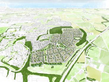
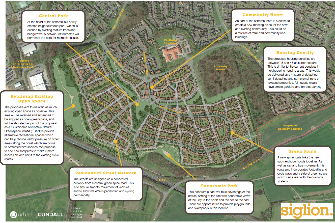
A major housing development is proposed at Chapelgarth’s 112-acre site as part of a 20-year regeneration programme in Sunderland. The landscape strategy aims to enhance the natural green space and provide parks and green spaces for current and new residents. There will be a green buffer between Weymouth road and the new development which will include drainage ponds for water management. At the heart will be Central Park, defined by the mature trees and hedge grows, which are already in place. A large "Sustainable Alternative Natural Greenspace" will be created and Sustainable Drainage Systems will be installed throughout the neighbourhood (Ref1).
Urbed
http://urbed.coop/projects/chapelgarth-sunderland
Overview
Nature-based solution
- Grey infrastructure featuring greens
- Alley or street trees and other street vegetation
- Parks and urban forests
- Large urban parks or forests
- Pocket parks/neighbourhood green spaces
- Community gardens and allotments
- Allotments
- Blue infrastructure
- Lakes/ponds
- Green areas for water management
- Rain gardens
- Swales and filter strips
- Sustainable urban drainage systems
Key challenges
- Water management (SDG 6)
- Flood protection
- Stormwater and rainfall management and storage
- Green space, habitats and biodiversity (SDG 15)
- Green space creation and/or management
- Health and well-being (SDG 3)
- Creation of opportunities for recreation
- Economic development and employment (SDG 8)
- Real estate development
Focus
Creation of new green areas
Project objectives
To develop village-style neighbourhoods in Chapelgarth with accessible open space in a way that protects the woodland areas, naturally manages flood water, enhances natural greenspaces and creates new greenspaces (Ref 1).
Implementation activities
1. Create 150 new and diverse homes (5% to be 2 bedroom houses, 20% to be 5+ bedroom houses and 75% to be 3 or 4 bedroom houses), 2. Install swales (shallow vegetated channels to slow surface water run-off), 3. Install drainage ponds, 4. Plant trees to capture surface water, 5. Provide natural greenspace, 6. Maintain buffer zones around woodland areas and hedgerows, 7. Create a Central Park, 8. Create accessible (at least 2 hectares) woodland within 500 metres from every residential building, 9. All residents will live no more than 300 metres away from at least 2 hectares of accessible green space (ref 1 & 2), 10. Two areas are allocated to become allotments (Ref 2), 11. Create raised earth bund and green barrier to deflect noise from the A19. (Ref 2)
Main beneficiaries
- Local government/Municipality
- Citizens or community groups
Governance
Management set-up
- Co-governance with government and non-government actors
Type of initiating organisation
- Local government/municipality
- Private sector/corporate actor/company
Participatory approaches/ community involvement
- Consultation (e.g. workshop, surveys, community meetings, town halls)
Details on the roles of the organisations involved in the project
"Siglion" is an innovative development partnership between Carillion (private sector) and Sunderland City Council, the management of which is done by igloo Regeneration (private sector) (Ref 3). This partnership is the main driver of the project. In 2019, Siglion was taken over by the Sunderland City Council. (Ref 1, 3 and 8).
Project implemented in response to ...
... an EU policy or strategy?
Unknown
... a national policy or strategy?
Yes
(1. All residents will live no more than 500m from at least two hectares of accessible woodland, in line with The Woodland Trust’s Woodland Access Standard Nature Nearby, 2. All residents will live no more than 300m from at least two hectares of accessible green space in line with Natural England Accessible Natural Greenspace (Ref 1). )
... a local policy or strategy?
Yes
(1. The Unitary Development Plan of 1998 designates the site to accommode for housing growth (Ref 2), 2. The area is part of the South Sunderland Growth Area (Ref 2). )
Financing
Total cost
Unknown
Source(s) of funding
- Unknown
Type of funding
- Unknown
Non-financial contribution
Unknown
Impacts and Monitoring
Environmental impacts
- Environmental quality
- Improved air quality
- Reduced noise exposure
- Water management and blue areas
- Increased protection against flooding
- Improved stormwater management
- Green space and habitat
- Increased number of protection areas
- Increased green space area
- Increase in protected green space areas
- Increased number of species present
Economic impacts
- Other
Socio-cultural impacts
- Social justice and cohesion
- Improved liveability
- Improved access to urban green space
- Health and wellbeing
- Improved physical health
- Gain in activities for recreation and exercise
Type of reported impacts
Expected impacts
Presence of formal monitoring system
Unknown
Presence of indicators used in reporting
No evidence in public records
Presence of monitoring/ evaluation reports
No evidence in public records
Availability of a web-based monitoring tool
No evidence in public records
References
Ref 1: Urbed (2016) Chapelgarth, Sunderland. Retrieved from Source link on 11th November, 2020.
Ref 2: Siglion. (2016). Chapelgarth Masterplan January 2016 Exhibition Handout Booklet. Retrieved from Source link on 11th November, 2020.
Ref 3: Siglion. (n.d.). Welcome to Siglion. Retrieved from Source link
Ref 4: Sunderland Partnership. (2011). Green infrastructure strategy framework. [attached]
Ref 5: Sunderland City Council (2016). Chapelgarth, Sunderland: Statement of Community Involvement. Retrieved from Source link on 11th November, 2020.
Ref 6: Make it Sunderland. (n.d.). Chapelgarth. Retrieved from Source link on 11th November, 2020.
Ref 7: Thompson, F. (2020) £25 million bid to help support 4,000 new homes in Sunderland wins Government backing. Sunderland Echo. Retrieved from Source link on 11th November, 2020.
Ref 8: Ford, C. (2019) Sunderland council takes over Siglion to drive forward multimillion pound city vision. Chronicles live. Retrieved from Source link on 11th November, 2020.
Sunderland City Council
https://www.sunderland.gov.uk/media/19969/3-Statement-of-Community-Involvement/pdf/3._Statement_of_Community_Involvement.pdf?m=636523936814170000