
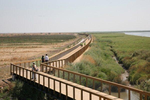
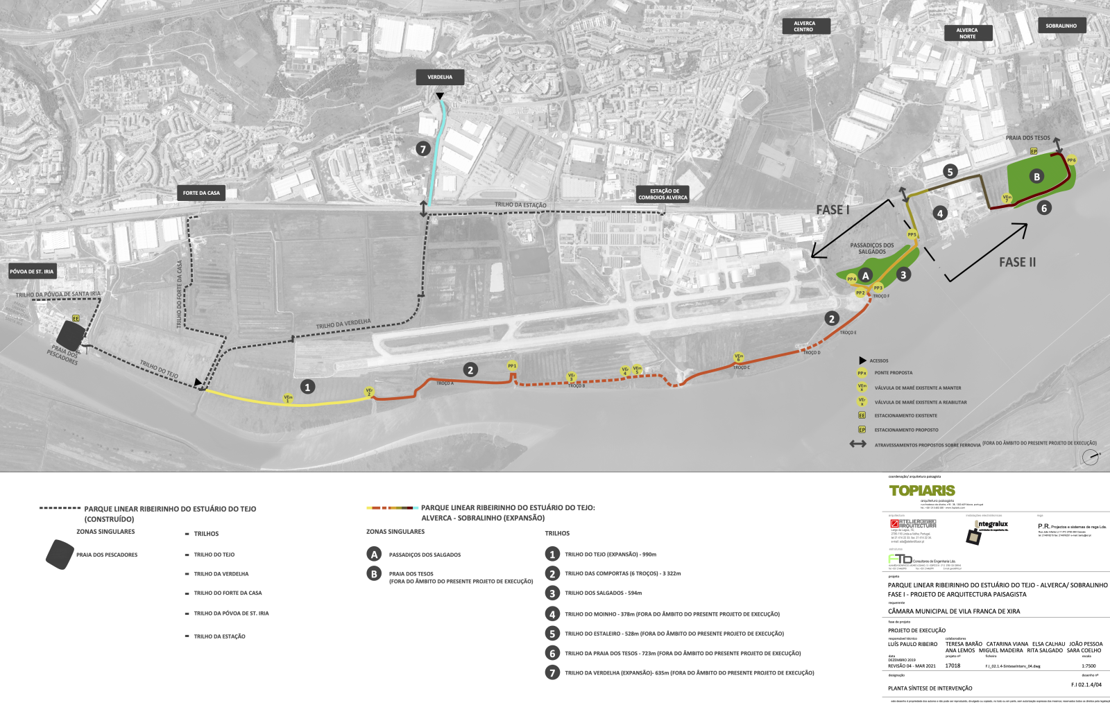
The Tagus Estuary Linear Riverside Park is a significant environmental and recreational project in Vila Franca de Xira. As part of a broader urban regeneration initiative, the park aimed to enhance the natural and cultural landscape by promoting ecological regeneration while providing public access to the Tagus River (Ref 1). Created in 2013, the park has won several international awards and since then, the park has undergone several extensions. In 2017, another 700-meter walkway was added towards Santa Iria, and the inhabitants of this urban area of Vila Franca de Xira widely use it (Ref. 6). The park covers over 14 hectares and includes pedestrian and cycling paths, environmental education facilities such as the Bird Observatory, and the Environmental and Landscape Interpretation Centre (Ref 2). Recently announced in 2023, the park's newest expansion is set to extend the riverside trails further, creating a continuous route from Lisbon to Alhandra (Ref 5). With future phases planned, the project is expected to significantly increase public interaction with the riverfront and its biodiversity (Ref 5). In this new project phase, the Vila Franca de Xira Municipal Council begins the requalification and environmental and landscape conservation of another section of the riverfront of the Municipality of Vila Franca de Xira, between Alverca and Sobralinho, covering an extension of approximately 4.9 km and an area of approximately 14.1 hectares (Ref. 7). The extension of the park will be developed similarly to its existing infrastructure. New paths for pedestrians and cyclists will be created using elevated wooden structures (walkways). In total, two new cycle-pedestrian trails will be created – Trilho das Comportas (3.32 kilometres long) and the Trilho dos Salgados (594 metres long) –, and the Trilho do Tejo will be extended by a further 990 metres (Ref. 5).
Overview
Nature-based solution
- Parks and urban forests
- Large urban parks or forests
Key challenges
- Climate action for adaptation, resilience and mitigation (SDG 13)
- Climate change adaptation
- Green space, habitats and biodiversity (SDG 15)
- Green space creation and/or management
- Habitat and biodiversity restoration
- Water management (SDG 6)
- Flood protection
- Health and well-being (SDG 3)
- Creation of opportunities for recreation
- Enabling opportunities for physical activity
- Social justice, cohesion and equity (SDG 10)
- Environmental education
Principal problems in Functional Urban Area (FUA)
- Environmental Degradation
- Biodiversity loss
- Land use and Socio-economic change
- Unequal availability and access to public green spaces
Key priorities
Focus
Project objectives
Implementation activities
Climate-focused activities
Climate change adaptation:
- Increase urban vegetation cover to reduce urban heat island effect
- Protect and restore coastal ecosystems, to address loss of land and livelihoods, due to rising sea levels
Biodiversity conservation or restoration-focused activities
Biodiversity restoration:
- Restore species (native, endangered, or unspecified)
- Restore native species
Main beneficiaries
- Citizens or community groups
Governance
Management set-up
- Government-led
Type of initiating organisation
- Local government/municipality
Participatory approaches/ community involvement
- The project didn't involve any form of stakeholder participatory activities
Details on the roles of the organisations involved in the project
Project implemented in response to ...
Type of enablers
Financing
Total cost
Source(s) of funding
- Public local authority budget
- EU funds
Type of funding
- Earmarked public budget
- Direct funding (grants, subsidies, or self-financed projects by private entities)
Non-financial contribution
Impacts and Monitoring
Environmental impacts
- Green space and habitat
- Increased green space area
- Achieved increased green space area
- Increase in protected green space areas
- Achieved increase in protected green space areas
- Increased conservation or restoration of ecosystems
- Achieved increased conservation or restoration of ecosystems
- Increased number of species present
- Achieved increased number of species present
Economic impacts
- Unknown
Socio-cultural impacts
- Health and wellbeing
- Gain in activities for recreation and exercise
- Achieved gain in activities for recreation and exercise
- Cultural heritage and sense of place
- Improvement in people’s connection to nature
- Expected improvement in people’s connection to nature
- Education
- Increased awareness of NBS and their benefits
- Expected increased awareness of NBS and their benefits
Type of reported impacts
Presence of formal monitoring system
Presence of indicators used in reporting
Presence of monitoring/ evaluation reports
Availability of a web-based monitoring tool
Potential risks of implementation and trade-offs
References


 Information about this nature-based solution was collected as part of the Naturescapes project funded by the European Union under Grant Agreement No 101084341.