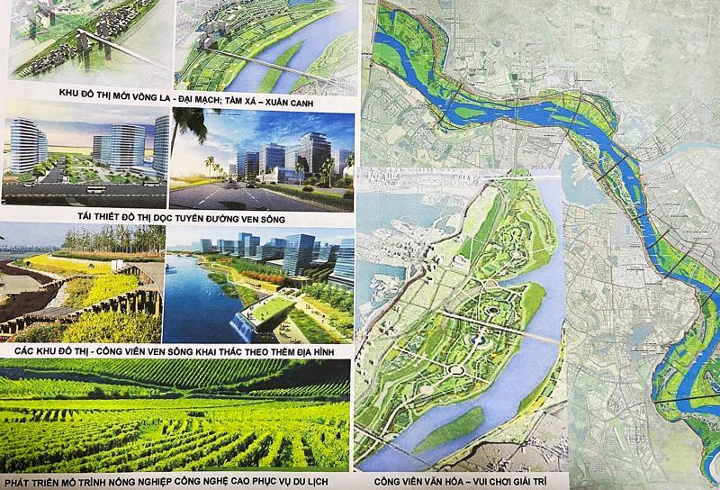
Vietnam's capital, Hanoi, is the second largest city in the country and is one of the most vulnerable to climate change. The city is located on the western bank of the Red River, the principal river of northern Vietnam. Throughout the centuries authorities in Hanoi built dykes to protect the city from the instability of the Red River. Though these dykes were built at a high altitude, the floods became more intense due to the huge amount of alluvium that rests in the middle of the river and that could not continue to consolidate on the banks and making water levels higher and more dangerous. Furthermore, outside the dykes, in the riverine zones (which play a role as green corridors to connect the city and the river) economically disadvantaged people built settlements contributing to soil erosion (caused by illegal construction and excessive sand exploitation), subpar soil quality, and poor waste management. (1,2) The Red River Zoning Plan (RRZP) came as a solution to address the issues before mentioned and has been promoted by the Hanoi People’s Committee. The plan is encompassing an area of about 11,000 hectares in 13 districts. The plan was approved by the Hanoi People's Committee in March 2022 at a size of 1/5000 section from Hong Ha Bridge to Me So Bridge. (1,4) According to the concept, a 40-kilometre-long new metropolitan area would be created on both banks of the Red River. This urban space would be a flood drainage area for downtown. It will be designed with a green landscape including public spaces for cultural and tourism purposes. For this, the city would invest in a network of transport and technical infrastructure to bolster connectivity in terms of roads and waterways with neighbouring areas. Particularly, the RRZP is building three types of new parks near the riverbanks, including a nature conservation park, an agricultural park, and an urban park to improve climate change adaptation and bring more natural elements to the city. (1, 4)

Overview
Nature-based solution
- Blue infrastructure
- Rivers/streams/canals/estuaries
- Green areas for water management
- Sustainable urban drainage systems
- Grey infrastructure featuring greens
- Riverbank/Lakeside greens
- Parks and urban forests
- Large urban parks or forests
Key challenges
- Climate action for adaptation, resilience and mitigation (SDG 13)
- Climate change adaptation
- Environmental quality
- Waste management
- Green space, habitats and biodiversity (SDG 15)
- Green space creation and/or management
- Water management (SDG 6)
- Flood protection
- Social justice, cohesion and equity (SDG 10)
- Environmental and climate justice
Focus
Project objectives
Implementation activities
Climate-focused activities
Climate change adaptation:
- Protect coastal and freshwater ecosystems to prevent coastal erosion and pollution
Main beneficiaries
- Local government/Municipality
- Citizens or community groups
- Marginalized groups: Socio-economically disadvantaged populations (e.g. low-income households, unemployed)
Governance
Management set-up
- Government-led
Type of initiating organisation
- Local government/municipality
Participatory approaches/ community involvement
- Other
Details on the roles of the organisations involved in the project
Project implemented in response to ...
Financing
Total cost
Source(s) of funding
- Public local authority budget
- Public national budget
- Corporate investment
- Other
Type of funding
- Earmarked public budget
- Direct funding (grants, subsidies, or self-financed projects by private entities)
- Other
Non-financial contribution
Impacts and Monitoring
Environmental impacts
- Water management and blue areas
- Increased protection against flooding
Economic impacts
- Attraction of business and investment
Socio-cultural impacts
- Social justice and cohesion
- Fair distribution of social, environmental and economic benefits of the NBS project
Type of reported impacts
Presence of formal monitoring system
Presence of indicators used in reporting
Presence of monitoring/ evaluation reports
Availability of a web-based monitoring tool
References
2. Vu Ngoc Anh, Pham Quynh Phuong, Le Quang Binh (2022), THE RED RIVER PLANNING OF HANOI IN THE CONTEXT OF URBANISATION AND MODERNISATION, available at Source link (accessed February 02, 2023).
3. Vietnam Urban Planning and Development Association. (2022). Hanoi: Approving the planning of urban zoning of the Red River passing through 13 districts. available at Source link (accessed on January 25, 2023).
4. My, H. (2022). Cảnh quan ở phân khu đô thị sông Hồng được quy hoạch thế nào? [How does the landscape in the Red River Zoning Plan look like?]. available at Source link (accessed on January 25, 2023).
5. My, H. (2022). Hơn 20 năm quy hoạch sông Hồng và quỹ đất 'vàng' của Hà Nội [More than 20 years of planning the Red River and the 'golden' land areas of Hanoi]. available at Source link (accessed on January 25, 2023).
6. Voice of Vietnam (VOV). (2022). Phát triển đô thị ven sông Hồng: Nguồn lực từ đâu? [ Urban development along the Red River: Where do resources come from?]. available at Source link (accessed on January 25, 2023).
7. Nguoi Dothi (2022), Quy hoạch đô thị ven sông Hồng: Khai thác quỹ đất mới để tạo không gian phát triển hài hoà, available at Source link (accessed February 11, 2023).
8. VietnamNet (2020), Planning on Red River banks need pushing up, available at Source link (accessed March 4, 2023).