
Last updated: November 2021
The scheme was designed to manage surface water runoff from a 1 in 30 year event and to always intercept and treat the, often more polluted, first flush of highway runoff (ref. 1). A total of 21 linear rain gardens (total of 148m2) were constructed within the grass verge, allowing for the constraints of access, below-ground services, street furniture and trees. The rain gardens utilise a combination of clean stone aggregate and proprietary units to create void space beneath a planted topsoil layer. They were designed to capture runoff from 5500 m2 of highway from a total surface area of 7100 m2 (ref. 1).
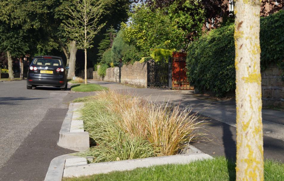
Rain gardens in Nottingham
https://www.susdrain.org/case-studies/case_studies/greening_streets_retrofit_rain_gardens_nottingham.html
Overview
Nature-based solution
- Green areas for water management
- Rain gardens
- Sustainable urban drainage systems
Key challenges
- Climate action for adaptation, resilience and mitigation (SDG 13)
- Climate change adaptation
- Water management (SDG 6)
- Flood protection
- Stormwater and rainfall management and storage
- Improvements to water quality
- Regeneration, land-use and urban development
- Promote natural styles of landscape design for urban development
- Inclusive and effective governance (SDG 16)
- Inclusive governance
Focus
Creation of new green areas, Improved governance of green or blue areas
Project objectives
The pilot retrofit SuDS project was designed to achieve the following objectives:
“Document and evaluate the design and construction of a series of rain gardens within an existing highway setting;
Maximise surface water interception, attenuation and infiltration;
Test the effectiveness of rain gardens in managing surface water from the public highway;
Encourage participation from local residents in the design and future management of the rain gardens;
Evaluate the effectiveness of the scheme as an engagement tool around the sources of urban diffuse pollution and flood risk; Highlight the role that retrofit SuDS can play in improving the quality and reducing the volume of surface water flowing to urban watercourses” (ref. 1)
Implementation activities
“A total of 21 linear rain gardens (total of 148m2) were constructed within the grass verge. The scheme was designed to manage surface water runoff and to always intercept and treat the, often more polluted, first flush of highway runoff. Existing highway gullies have been retained to allow for overflow when the rain gardens reach capacity. Budget constrains meant that the use of proprietary cells was reduced and replaced by stone fill in a number of gardens. It is hoped that differences in the performance of the 2 different rain garden designs will be evaluated over the coming years” (ref. 1) The primary principle was to ensure effectiveness in managing downstream water quality and flooding. As part of this, aesthetic benefits were an important consideration, to ensure no loss of the green areas already limited within the urban environment. Part of the purpose of this pilot study was to understand the public perception and acceptability of rain gardens. (ref. 2).
Climate-focused activities
Climate change adaptation:
- Restore wetlands and/or coastal ecosystems to dissipate the effects of flooding and/or storms
- Implement sustainable urban drainage infrastructure (e.g. to make space for water)
Main beneficiaries
- Local government/Municipality
- Non-government organisation/Civil Society
- Citizens or community groups
Governance
Management set-up
- Co-governance with government and non-government actors
Type of initiating organisation
- National government
- Local government/municipality
- Non-government organisation/civil society
- Citizens or community group
- District/neighbourhood association
Participatory approaches/ community involvement
- Co-planning (e.g. stakeholder workshops, focus groups, participatory mapping)
- Taskforce groups
- Citizen monitoring and review
Details on the roles of the organisations involved in the project
The pilot retrofit SuDS project was a result of collaboration between the Environment Agency (Financial; guidance; evaluation), Nottingham City Council (Construction; design; maintenance), Groundwork Greater Nottingham (Design; implementation; community liaison) and Severn Trent Water (post construction modelling). The project was initiated by Environment Agency and Nottingham City Council (ref. 1, 2)
Project implemented in response to ...
... an EU policy or strategy?
Yes
(EU's Water Framework Directive (WFD); Reducing/mitigating flood risks (Floods Directive). (Ref. 3) )
... a national policy or strategy?
Unknown
... a local policy or strategy?
Yes
(“Urban diffuse pollution programme across the region.” (Ref. 3)
["Within the highly urbanised area of Nottingham City, a total of 972 properties fall within the Day Brook floodplain, with previous fluvial events leading to property flooding downstream. Ribblesdale Road is parallel to some of the upper reaches of Day Brook, a heavily modified watercourse that has poor water quality due in part to numerous sources of diffuse pollution from the extensive urban catchment."] (Ref. 3) )
Financing
Total cost
€50,000 - €100,000
Source(s) of funding
- Public national budget
- Public local authority budget
Type of funding
- Earmarked public budget
- Direct funding (grants, subsidies, or self-financed projects by private entities)
Non-financial contribution
Type of non-financial contribution
- Provision of labour
Who provided the non-financial contribution?
- Citizens (e.g. volunteering)
Impacts and Monitoring
Environmental impacts
- Water management and blue areas
- Improved water quality
- Increased protection against flooding
- Improved stormwater management
- Green space and habitat
- Promotion of naturalistic styles of landscape design for urban development
- Increased green space area
Economic impacts
- Unknown
Socio-cultural impacts
- Social justice and cohesion
- Increased involvement of locals in the management of green spaces
- Cultural heritage and sense of place
- Increased appreciation for natural spaces
- Education
- Increased support for education and scientific research
- Increased awareness of NBS and their benefits
Type of reported impacts
Expected impacts, Achieved impacts
Presence of formal monitoring system
Yes
Presence of indicators used in reporting
Yes
Presence of monitoring/ evaluation reports
Yes
Availability of a web-based monitoring tool
No evidence in public records
References
1. Susdrain. (n.d.) Greening streets, retrofit rain gardens, Nottingham. Case study. Accessed 17 July 2020. Available at: Source link
2. European Commission. (2013). Case study Rain Garden Nottingham. Final Version. Accessed 17 July 2020. Available at: Source link
3. Nottingham City Council. (n.d.) Lead Local Flood Authority. Accessed 17 July 2020. Available at: Source link
4. Restoring Europe's Rivers. (n.d.). Case study:Day Brook Rain Gardens. Accessed 17 July 2020. Available at: Source link
5. NWRM European Commission. (n.d.) Rain gardens for the Day Brook, UK. Case Study. Natural Water Retention Measures. Accessed 17 July 2020. Available at: Source link