, United Kingdom
City population: 478344
Duration: 2015 – ongoing
Implementation status: Ongoing
Scale: Meso-scale: Regional, metropolitan and urban level
Project area: unknown
Type of area: Central Business District / City Centre
Last updated: October 2021

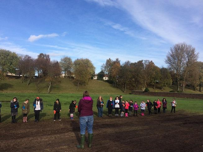
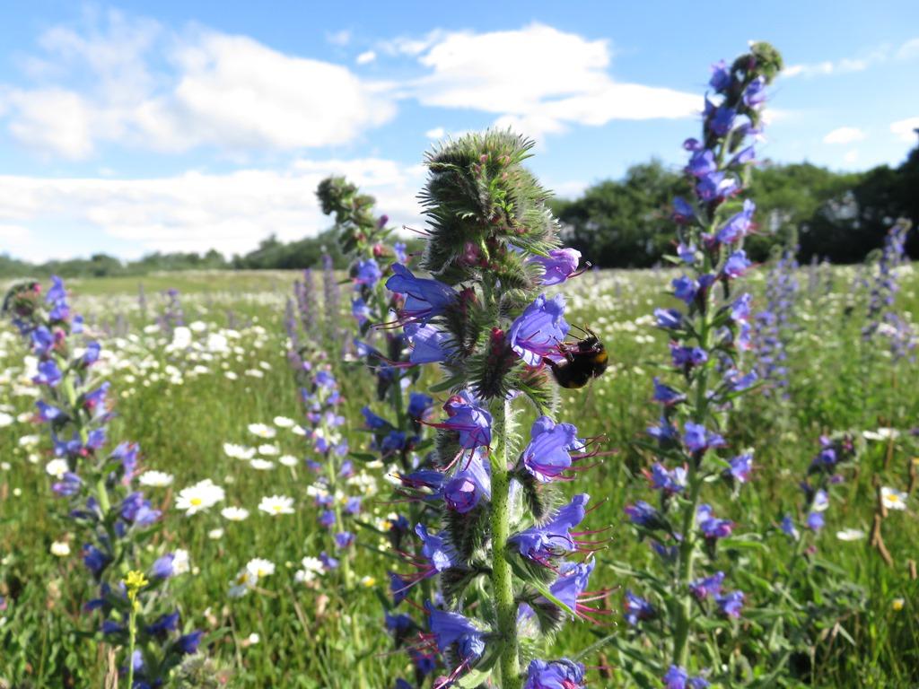
The John Muir Pollinator Way is an initiative by the NGO Buglife to create and restore pollinator habitats along a 215 km long-distance active travel route – The John Muir Way – across the densely populated central belt of Scotland. The John Muir Pollinator Way is the first B-Line ‘pathway’ in Scotland and stretches from Helensburgh in the west to Dunbar in the east (Emilie). It is an ambitious project given the length (215 km) of this pathway. It connects nine different local authorities and 40 km of the total length falls within the Edinburgh local authority area (Burgess, 2016). This not only serves to halt the process of declining pollinator numbers providing crucial ecosystem services, but also helps people to connect with nature. Between July 2015 and March 2017, project partners and volunteers have transformed 19 sites into species-rich grassland. [ref 1]

Buff Tailed Bee (Bombus terrestris) at the Grangepans Site Visit (2017)
Photographer: Suzanne Burgess, retrieved 09/04/2018

Overview

Nature-based solution

  • Parks and urban forests
  • Green corridors and green belts

Key challenges

  • Green space, habitats and biodiversity (SDG 15)
  • Habitat and biodiversity restoration
  • Habitat and biodiversity conservation
  • Green space creation and/or management
  • Regeneration, land-use and urban development
  • Promote natural styles of landscape design for urban development
  • Inclusive and effective governance (SDG 16)
  • Inclusive governance

Focus

Creation of new green areas, Monitoring and maintenance of habitats and/or biodiversity

Project objectives

1. To help conserve pollinators and support the services they provide to the farming sector. 2. To bring nature closer to people. 3. To link existing wildlife areas together, creating a network that will weave across the British landscape. 4. To provide large areas of brand new habitat benefiting bees and butterflies as well as a host of other wildlife. 5. The aim of the second phase of this project – which ran from September 2018 to June 2019 – was to create at least 25 pollinator ‘hubs’ along the John Muir Way, building on work carried out in previous years and increasing the amount of wildflower habitat available to boost pollinator populations in Central Scotland. [ref 3, 4]

Implementation activities

Broadly three project phases can be identified in the development of the John Muir Pollinator Way, each of which has received funding from a different source. In the first phase, like with all B-Line projects, mapping of the insect ‘pathway’ took place. Pollinator habitats, as well as areas suitable for habitat creation and/or improvement, were mapped, using aerial photography and maps. In the second phase, Buglife and the by Central Scotland Green Network Trust (CSGNT) worked with local authorities, Friends of Parks groups and other partners in order to restore 19 sites, mainly local authority owned. This was done by seeding wildflowers and putting in plug plants. At the same time, the project also ran through a third phase which was about public engagement and outreach using workshops and field trips. A school pack was created "Planting for Pollinators Along the John Muir Way" as an educational resource. [ref 1]

Biodiversity conservation or restoration-focused activities

Biodiversity conservation:

  • Protect and enhance urban habitats
  • Create new habitats
  • Preserve and strengthen habitat connectivity
  • Protect species
  • Undertake specific measures to protect species
  • Means for conservation governance
  • Biodiversity offsets

Biodiversity restoration:

  • Restore species (native, endangered, or unspecified)
  • Restore ecological connectivity

Main beneficiaries

  • Public sector institution (e.g. school or hospital)
  • Citizens or community groups
  • Young people and children

Governance

Management set-up

  • Co-governance with government and non-government actors

Type of initiating organisation

  • Regional government
  • Local government/municipality
  • Public sector institution
  • Non-government organisation/civil society

Participatory approaches/ community involvement

  • Co-planning (e.g. stakeholder workshops, focus groups, participatory mapping)
  • Dissemination of information and education
  • Consultation (e.g. workshop, surveys, community meetings, town halls)
  • Joint implementation (e.g. tree planting)
  • Co-management/Joint management
  • Citizen monitoring and review

Details on the roles of the organisations involved in the project

Buglife is the lead partner with support from the Central Scotland Green Network Trust (CSGNT) and Scottish Natural Heritage (SNH). Implementation is done together with local authorities, Friends of Parks groups, schools and a small number of environmental organisations. City of Edinburgh Council is responsible for maintenance as part of their current policy of renaturalising parks and greenspaces as part of their engagement with the Edinburgh Living Landscape partnership. [ref 1]

Project implemented in response to ...

... an EU policy or strategy? Unknown
... a national policy or strategy? Yes (The Pollinator Way project fits in very well with national policy, in particular the Pollinator Strategy for Scotland 2017-2027, which contributed to its success in obtaining funding from CSGNT. In addition, it also links in with the forthcoming 2018-19 Programme for Government, an annual document setting out Scottish Government’s priorities, in which it will be described as a case study (Int4). Another important document is the National Planning Framework 3 (NPF 3) in which the Central Scotland Green Network –within which the John Muir Way is a flagship project. [ref 1])
... a local policy or strategy? Yes (The city’s Local Development Plan outlines policies regarding new housing development and associated urban infrastructure, providing a 10-year vision of spatial development within the city that is informed by national policy. The policies take into account regional spatial planning objectives as outlined in the South East Scotland Strategic Development Plan, which is prepared by the regional planning authority SESplan. They are also in the process of Green Networks Technical Note, which will inform a strategically planned regional green infrastructure. A second local policy document relevant to nature-based solutions in the city is Edinburgh’s Open Space Strategy. It serves to “ensure that a coordinated approach is taken to meeting Edinburgh’s open space needs and protecting and developing the city’s network of open spaces." The strategy has a strong focus on health and well-being and provides quantity, quality and accessibility indicators for urban green spaces. [ref 1])

Financing

Total cost

€50,000 - €100,000

Source(s) of funding

  • Public regional budget
  • Private Foundation/Trust

Type of funding

  • Direct funding (grants, subsidies, or self-financed projects by private entities)

Non-financial contribution

Type of non-financial contribution
  • Provision of land
  • Provision of goods
  • Provision of labour
  • Other
Who provided the non-financial contribution?
  • Public authorities (e.g. land, utility services)
  • Private sector (businesses, financial institution)

Impacts and Monitoring

Environmental impacts

  • Green space and habitat
  • Promotion of naturalistic styles of landscape design for urban development
  • Reduced biodiversity loss
  • Increased protection of threatened species
  • Enhanced support of pollination
  • Increased ecological connectivity across regeneration sites and scales

Economic impacts

  • Attraction of business and investment

Socio-cultural impacts

  • Social justice and cohesion
  • Increased involvement of locals in the management of green spaces
  • Cultural heritage and sense of place
  • Improvement in people’s connection to nature
  • Education
  • Increased support for education and scientific research
  • Increased knowledge of locals about local nature

Type of reported impacts

Expected impacts, Achieved impacts

Presence of formal monitoring system

Unknown

Presence of indicators used in reporting

No evidence in public records

Presence of monitoring/ evaluation reports

No evidence in public records

Availability of a web-based monitoring tool

No evidence in public records

References

Seeds Sowing by Carmuirs Primary (2017)
Photographer: Kirsty Grant, retrieved 09/04/2018 from Suzanne Burgess