
Last updated: October 2021
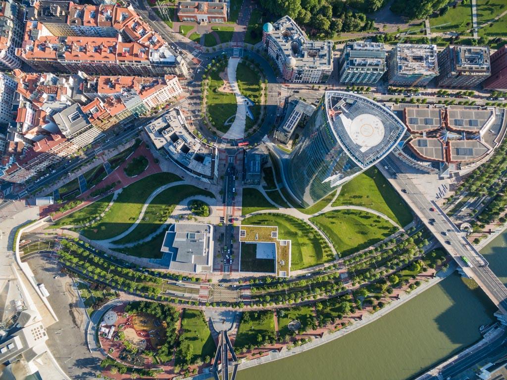
Abandoibarra is an area of the town of Bilbao, next to the Bilbao estuary, sizing 348,500 square meters. Abandoibarra has been the industrial zone of Bilbao, where shipyards and other companies related to the industrial sector were located. Building upon the 1997 master plan completed by Balmori Associates, Pelli Clarke Pelli Architects and Aguinaga y Asociados, the area has been reinvented as an international cultural district and tourist destination. Two-thirds of the 30-hectare site is dedicated to parks and open spaces, creating a public oasis and grounds for a suite of buildings by master architects (Ref 1,2).
Source: https://archframe.net/#abandoibarra-masterplan-landscape-bilbao-spain
Overview
Nature-based solution
- Grey infrastructure featuring greens
- Alley or street trees and other street vegetation
- Railroad bank and track greens
- Blue infrastructure
- Riverbank/Lakeside greens
- Parks and urban forests
- Pocket parks/neighbourhood green spaces
Key challenges
- Green space, habitats and biodiversity (SDG 15)
- Green space creation and/or management
- Regeneration, land-use and urban development
- Regulation of built environment
- Promote natural styles of landscape design for urban development
- Health and well-being (SDG 3)
- Creation of opportunities for recreation
- Economic development and employment (SDG 8)
- Tourism support
Focus
Creation of new green areas, Transformation of previously derelict areas
Project objectives
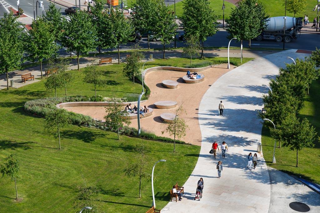
This intervention is part of a broader effort for urban regeneration in Bilbao. (Ref 4,5) It aims to transform the derelict industrial area of the Abandoibarra district to an international cultural district and tourist destination. Its design considerations include: expanding the amount of textured green space, incorporating sustainable design practices, making Abandoibarra the most pedestrian-friendly neighborhood of Bilbao, and unifying the Abandoibarra with the Nervion River. (Ref 1)
Implementation activities
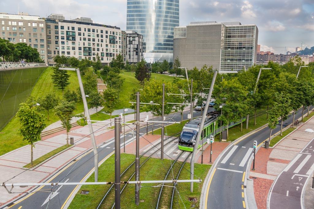
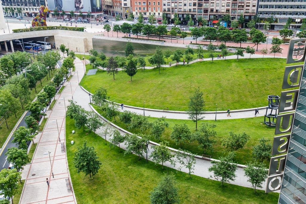
The project made Abandoibarra an integral part of the city by extending the city grid to the area and by adding new green spaces that link to existing ones. A linear park links the 19th-century Doña Casilda Park with the river’s edge. The project created a long promenade beginning at the old park, passing the museum and concert hall, Abandoibarra’s two cultural focal points. The large drop from the street to the river was corrected by creating a smooth sloping street that comfortably accommodates pedestrians. The pedestrian edge of the river has two levels: The lower level allows pedestrians to walk near the water. A parallel walkway on the second tier is a more formal promenade. Large streetlights along the walkway recall the scale of the cranes found in the old port. (Ref 2)
A new light rail connects the Guggenheim Museum and the Euskalduna Conference Centre and Concert Hall with the rest of the city. (Ref 1,3) The rail line runs on a width of green lawn to give continuity to the greenspace. (Ref 2) To slow down vehicles, a main high-speed roadway became a boulevard with ample pedestrian crossings. (Ref 1,3)
Main beneficiaries
- Local government/Municipality
- Citizens or community groups
Governance
Management set-up
- Co-governance with government and non-government actors
Type of initiating organisation
- Local government/municipality
- Other
Participatory approaches/ community involvement
- Co-planning (e.g. stakeholder workshops, focus groups, participatory mapping)
- Crowd-sourcing/Crowd-funding/Participatory budget
- Citizen oversight (e.g. boards, advisory)
Details on the roles of the organisations involved in the project
The project was implemented by BILBAO RIA 2000, a non-profit limited liability company (public enterprise). The remit of Bilbao Ria 2000 is "to recover degraded areas and run-down industrial zones in metropolitan Bilbao, thus helping achieve balanced development and making the city more cohesive". The creation of Bilbao Ria 2000 was initiated by the Ministry of Public Works and Transport and the Environment (currently the Ministry of Development) of the central Spanish Government. It represented a new management model for urban planning in Bilbao, in which stakeholders at different levels were to take part: the City Councils which traditionally held the urban planning and implementation powers, the Basque Government which possessed fiscal powers, and the central Spanish Government which owned most land in Bilbao. It has been expected that integrating public authorities in one company can create sufficient support for the Abandoibarra Project, minimize bureaucratic procedures, speeding up the execution. (Ref 4)
Balmori Associates, Pelli Clarke Pelli Architects and Aguinaga y Asociados: Developed master plan (Ref 1,2)
Private developers (various firms) & Universities: Buy land on Abandoibarra (Ref 4)
Project implemented in response to ...
... an EU policy or strategy?
Unknown
... a national policy or strategy?
Unknown
... a local policy or strategy?
Yes
(This NBS mentions the General Urban Zoning Plan of Bilbao (PGOUB) drawn up by the Bilbao City Council in 1987. PGOUB was a master plan for regenerating Bilbao. During the 1980s, the city was not only one of the worst polluted areas in Spain but also in rapid decline owing to the serious recession in its key economic sectors, such as mining, metallurgy, manufacturing and shipbuilding. Occupied by sparsely-used and state-owned port and railway facilities and derelict industrial sites, Abandoibarra was pinpointed by PGOUB as the most representative "opportunity site" left out by deindustrialization and economic decline that could be redeveloped to lead the urban regeneration of Bilbao (Ref 4) )
Financing
Total cost
Unknown
Source(s) of funding
- Other
Type of funding
- Other
Non-financial contribution
Unknown
Impacts and Monitoring
Environmental impacts
- Green space and habitat
- Promotion of naturalistic styles of landscape design for urban development
- Increased green space area
- Increased ecological connectivity across regeneration sites and scales
Economic impacts
- Stimulate development in deprived areas
- Attraction of business and investment
- Generation of income from NBS
Socio-cultural impacts
- Safety
- Increased perception of safety
- Social justice and cohesion
- Improved access to urban green space
- Health and wellbeing
- Gain in activities for recreation and exercise
Type of reported impacts
Achieved impacts
Presence of formal monitoring system
Unknown
Presence of indicators used in reporting
No evidence in public records
Presence of monitoring/ evaluation reports
No evidence in public records
Availability of a web-based monitoring tool
No evidence in public records
References
1. Architizer. (2020). BILBAO WATERFRONT ABANDOIBARRA MASTER PLAN. Available at: Source link [Accessed: 6 October 2020].
2. García Estellés, A., López De Lucas, A., & Martí Isas, J. (2016). PROVIDING EXAMPLES POSITIVE: ABANDOIBARRA MASTER PLAN, BILBAO NEGATIVE: GRAO MASTER PLAN, VALENCIA. Available at: Source link [Accessed: 6 October 2020].
3. Balmori Associates. (n.d.). Abandoinbarra Masterplan. Available at: Source link [Accessed: 6 October 2020].
4. Legislative Council Secretariat. (2005). Management, Operation and Financing of a Cultural District: The Case of Abandoibarra in Spain. [Document provided].
5. Bilbao Port. (n.d). Urban Regeneration. Available at: Source link [Accessed: 6 October 2020].
Source: https://archframe.net/#abandoibarra-masterplan-landscape-bilbao-spain
Source: https://archframe.net/#abandoibarra-masterplan-landscape-bilbao-spain
Source: https://archframe.net/#abandoibarra-masterplan-landscape-bilbao-spain